1. Where Eastport Is
Eastport is in Wildwood, Florida (ZIP 34762), south of SR 44, next to the Southern Oaks villages of Edenfield, Well Point, and Merritt Field. Public OpenStreetMap and Nominatim data place it at about 28.763 N, 81.986 W. It is several miles south of CR 466A.
The developer's April 6, 2022 "Continuing the Dream" article describes Eastport as located between the future Southern Oaks Bridge and County Road 470, renamed Central Parkway, and says plans bring a town square, a regional size recreation complex, golf, entertainment, shopping, and dining into one location (thevillages.com/eastport, checked November 3, 2026). That page describes plans and does not list what is open today, so check current hours and openings directly before you visit.
2. Golf Cart Reach Map
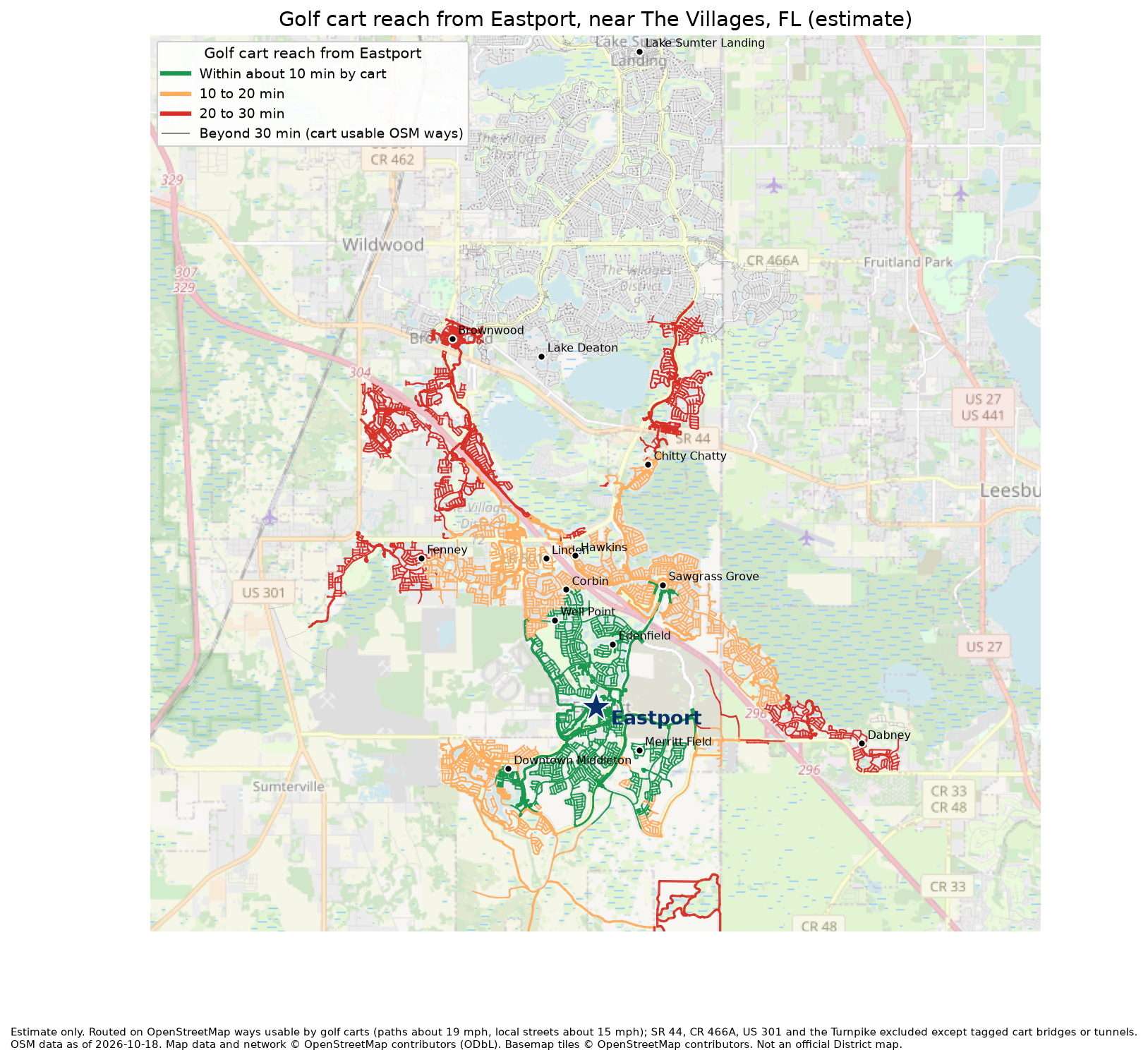
3. Estimated Cart Times From Eastport
All distances and times below are estimates from OpenStreetMap data (as of October 18, 2026), not official District routes or figures. Times assume about 19 mph on multimodal and cart paths and about 15 mph on local streets; the two columns show the full trip at each speed as a range. Real trips add stops, gates, and parking.
| From | Cart route distance (mi, OSM estimate) | Est. time at 19 mph | Est. time at 15 mph | Route notes |
|---|---|---|---|---|
| Village of Edenfield | 1.7 | 5 min | 7 min | about 5% on multimodal or cart paths, rest on local streets shared with cars; main ways: Caudill Trail, Provencher Path, Schneller Avenue, Pearl Place |
| Merritt Field (Merritt Field Run) | 2.2 | 7 min | 9 min | 2 tunnel segment(s) tagged in OSM (Multi-Modal Tunnel, Tunnel); about 50% on multimodal or cart paths, rest on local streets shared with cars; main ways: Merritt Field Run, Busche Boulevard, Mcpherson Terrace |
| Village of Well Point | 2.4 | 7 min | 9 min | about 4% on multimodal or cart paths, rest on local streets shared with cars; main ways: Corbin Trail, Katelyn Avenue, Pearl Place, McNeill Drive |
| Corbin (Corbin Trail) | 2.5 | 8 min | 10 min | about 3% on multimodal or cart paths, rest on local streets shared with cars; main ways: Corbin Trail, Pearl Place, Central Lake Drive, Mcpherson Terrace |
| Downtown Middleton | 2.8 | 9 min | 11 min | 1 tunnel segment(s) tagged in OSM (Multi-Modal Tunnel); about 65% on multimodal or cart paths, rest on local streets shared with cars; main ways: Sweny Drive, Neil Way, Dr Randy McDaniel Way |
| Sawgrass Grove | 3.1 | 10 min | 13 min | 3 tunnel segment(s) tagged in OSM (BT-1 Tunnel, BT-3 Tunnel, Tunnel); bridge(s): Southern Oaks Bridge; about 82% on multimodal or cart paths, rest on local streets shared with cars; main ways: Mcpherson Terrace, Southern Oaks Bridge, Beebe Court |
| Village of Linden | 3.2 | 10 min | 13 min | about 3% on multimodal or cart paths, rest on local streets shared with cars; main ways: Corbin Trail, Parkyn Path, Pearl Place, Grimes Court |
| Village of Hawkins | 5.1 | 16 min | 20 min | 4 tunnel segment(s) tagged in OSM (BT-1 Tunnel, BT-3 Tunnel, Tunnel); bridge(s): Southern Oaks Bridge; about 82% on multimodal or cart paths, rest on local streets shared with cars; main ways: Mcpherson Terrace, Southern Oaks Bridge, Matanzas Loop |
| Village of Fenney | 5.8 | 18 min | 23 min | 1 tunnel segment(s) tagged in OSM; about 58% on multimodal or cart paths, rest on local streets shared with cars; main ways: Fenney Way, Sweny Drive, Corbin Trail |
| Village of Chitty Chatty | 5.9 | 19 min | 24 min | 3 tunnel segment(s) tagged in OSM (BT-1 Tunnel, BT-3 Tunnel, Tunnel); bridge(s): Southern Oaks Bridge; about 84% on multimodal or cart paths, rest on local streets shared with cars; main ways: Mcpherson Terrace, Southern Oaks Bridge |
| Village of Dabney | 7.2 | 23 min | 29 min | includes a stretch of Meggison Road shared with cars, check posted cart rules; 3 tunnel segment(s) tagged in OSM (BT-1 Tunnel, BT-3 Tunnel, Tunnel); bridge(s): Southern Oaks Bridge; about 33% on multimodal or cart paths, rest on local streets shared with cars; main ways: Meggison Road, Chandler Drive, Baysinger Path |
| Brownwood (Paddock Square) | 8.8 | 28 min | 35 min | 4 tunnel segment(s) tagged in OSM (Tunnel); bridge(s): Bridge, Water Lilly Bridge; about 90% on multimodal or cart paths, rest on local streets shared with cars; main ways: Sweny Drive, Neil Way |
| Village of Lake Deaton | 11.0 | 35 min | 44 min | OSM shows no shorter cart link, so the route loops west; 4 tunnel segment(s) tagged in OSM (Tunnel); bridge(s): Bridge, Water Lilly Bridge; about 83% on multimodal or cart paths, rest on local streets shared with cars; main ways: Sweny Drive, Hillsborough Trail |
| Lake Sumter Landing | 14.6 | 46 min | 58 min | 4 tunnel segment(s) tagged in OSM (BT-1 Tunnel, BT-3 Tunnel, Tunnel); bridge(s): Chitty Chatty Bridge, Southern Oaks Bridge; about 93% on multimodal or cart paths, rest on local streets shared with cars; main ways: Mcpherson Terrace, Tunnel |
| Spanish Springs Town Square | 17.5 | 55 min | 70 min | long trip, plan for battery range; 4 tunnel segment(s) tagged in OSM (BT-1 Tunnel, BT-3 Tunnel, Tunnel); bridge(s): Bridge, Chitty Chatty Bridge, Southern Oaks Bridge; about 84% on multimodal or cart paths, rest on local streets shared with cars; main ways: Morse Boulevard |
Village start points are a single map point inside each village, so a trip from a given home can be a few minutes longer or shorter. Corbin and Merritt Field use a street of that name as a stand in.
4. What These Estimates Do Not Cover
- Missing newer paths. OpenStreetMap coverage is incomplete in the newest Southern Oaks and Eastport areas. Some cart paths, tunnels, and gates may be missing or untagged, which can make estimated routes longer (Lake Deaton likely) or occasionally shorter than reality.
- Gates and closures are not modeled. Gated entries, construction closures, and one way tunnels are not included.
- Shared roads. Some routes use local streets shared with cars, and the Dabney route includes a stretch of Meggison Road. Check posted cart rules.
- Not checked against District records. Official District cart path GIS data was not available for this guide.
- Slower carts take longer. Carts limited to 15 mph or slower will take the longer column or more.
5. How the Estimates Were Made
- An OpenStreetMap extract of the area (Overpass API, data as of October 18, 2026).
- Kept ways a golf cart can use: paths, cycleways, tracks, and footways tagged for golf carts, plus local streets at 35 mph or less. Dropped ways tagged golf_cart=no, under construction, or on SR 44, CR 466A, US 301, US 27/441, and SR 91, except tagged cart bridges and tunnels. No route uses SR 44 or CR 466A at grade.
- Routed the shortest time from Eastport (Hotel Eastport, Beebe Court, as placed in OpenStreetMap) to each start point.
Snowbird Checklist Before You Ride
- Confirm your cart's top speed and battery range against the longer trips.
- Ride a new route in daylight first and watch for gates, tunnels, and signs.
- Check current hours and openings at Eastport directly, since plans and openings change.
- Check posted cart rules on any road shared with cars.